What an Icelandic volcanic eruption looks like when viewed from space (8 photos + 1 video)
Images from the Copernicus Sentinel-2 satellite captured the incredible power of the latest eruption on Iceland's Reykjanes Peninsula. 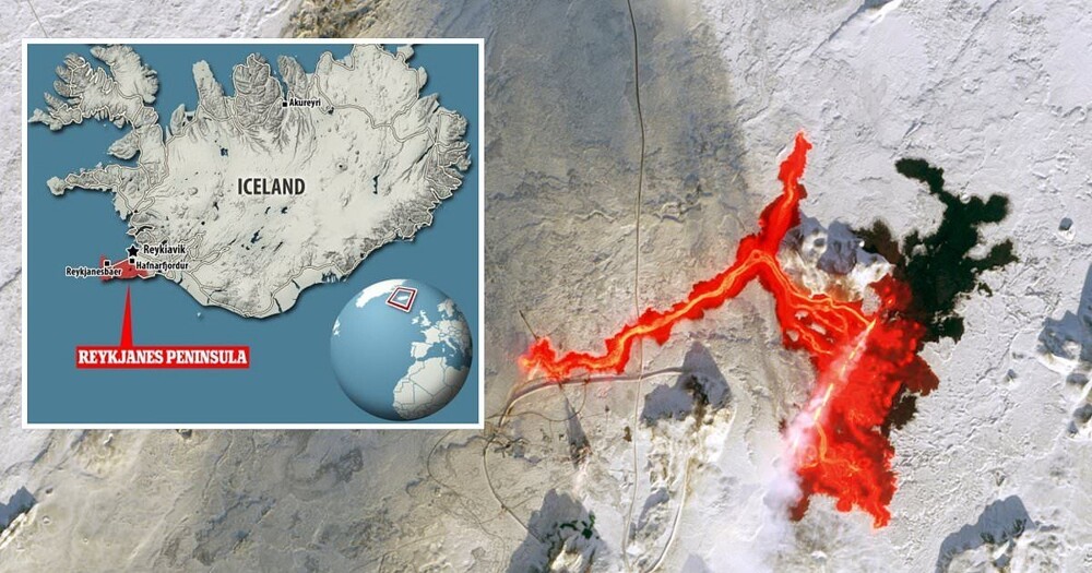
On February 8, residents of the Icelandic Reykjanes Peninsula faced the devastating consequences of another volcanic eruption.
The true scale of the disaster is shown in an image taken by the Copernicus SENTINEL-2 satellite just 10 hours after the eruption. The image shows a massive lava spill that has traveled up to 4.5 km to the west, destroying pipes that supply hot water to 20,000 people.
The image also shows how close the lava came to the vital Svartsengi power station. 
This is the third eruption on the Reykjanes Peninsula (in red) in the last three months. As a result, residents of the city of Grindavik were evacuated 
The eruption began on February 8 at approximately 5:30 am local time. The 3-kilometer fissure opened up and released streams of lava just 4 km north of Grindavik. 
The Icelandic Meteorological Office (IMO) estimates that nine million cubic meters of magma had accumulated in the volcanic chamber at the time of the eruption. When the pressure eventually became too much and the volcano erupted, this lava spilled out.
Previous eruptions on the Reykjanes Peninsula have sent lava flows south, passing dangerously close to Grindavik and the nearby power plant. In January, lava from the most dangerous eruption reached the outskirts of the city and destroyed at least three houses.
However, lava from the February 8 eruption moved mainly in a westerly direction. The Copernicus satellite image shows the lava formed into a long, thin stream and traveled 4.5 km from the eruption site.
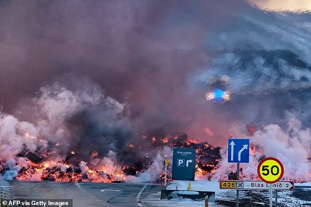
The lava flows traveled 4.5 km to the west and entered a key hot water pipe (pictured) near the Blue Lagoon tourist attraction 
The eruption released a huge plume of steam and gas, which can also be seen in satellite images. 
According to the IMO, this was most likely caused by lava interacting with groundwater, resulting in minor explosive activity.
Although the satellite image shows the plume passing over Grindavik, the IMO says there is no longer a risk of gas pollution in the city. The greatest danger to the city is posed by possible karst sinkholes and earthquakes.
However, closer to the lava flows, the danger of gas pollution is still considered likely.
This close-up of the satellite image shows how close the lava flows came to the city as the gas cloud swept over the previously populated area 
Although the latest eruption does not directly threaten any populated areas, its consequences have been extremely destructive.
Lava crashed into a key hot water pipe leading from the Svartsengi geothermal power plant.
The lava flow has disrupted hot water supplies to more than 20,000 homes and the local Civil Defense Agency has raised the alert level to emergency for the entire Reykjanes Peninsula region.
Work to repair the pipeline continues, but it may take several days before hot water supply is restored. There are also concerns that lava could impact key pipelines near the Svartsengi geothermal power plant.
If this happens, another 30,000 people will be affected. However, according to the IMO, the eruption has already subsided, meaning further damage is unlikely. The activity of volcanic tremors after February 8 in this area has decreased significantly, which means that the worst is now behind us.
However, experts believe the Reykjanes Peninsula has entered a new era of volcanic activity after eight centuries of inactivity. That is, similar eruptions are likely to recur in the coming months.
