Cities, rivers and something unexpected: what is shown on the oldest map of the Neo-Babylonian kingdom (3 photos)
Back in the 19th century, archaeologists discovered an ancient artifact known as the Babylonian World Map, but research into this subject continues. Scientists have discovered that this map depicts not only ancient cities, but also something completely different. 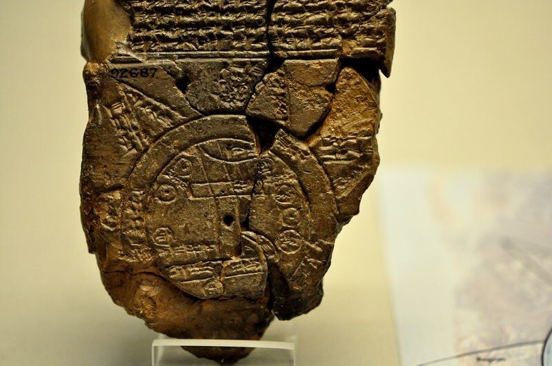
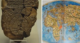
The "Imago Mundi" or Babylonian World Map is an artifact that is often considered the oldest map of the known world. Although the find is not as precise as modern maps, it provides a unique insight into how the ancient Babylonians saw themselves and their surroundings.
This map, created between 2600 and 2900 years ago, appeared during the heyday of the Neo-Babylonian Kingdom, a period marked by advances in architecture, culture, mathematics and early science.
According to Encyclopedia Britannica, archaeologist Ormuzd Rassam, known for excavating important Assyrian and Babylonian artifacts, particularly tablets from the Epic of Gilgamesh, found the map during an 1881 excavation at Sippar in what is now Iraq. However, some believe that it may have originated from Borsippa, another ancient city. 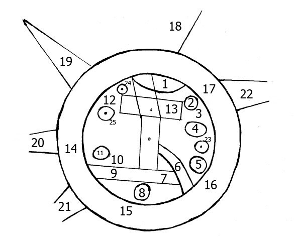
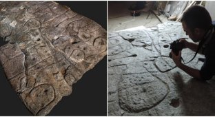
The cracked tablet, measuring 12.2 by 8.2 cm, now in the British Museum in London, contains a circular map with cuneiform text. Despite the absence of fragments, scientists have reconstructed most of its contents. The artifact outlines Mesopotamia and shows prominent ancient cities and cultures such as the Babylonians and Assyrians.
Babylon is depicted as a rectangular stripe at the top of the map, crossed by lines representing the Euphrates River. This famous river flows from the northern mountains through Babylon and ends in the southern swamps. Other cities, notably Assyria, Der and Urartu, are surrounded by a strip representing the ocean, which is called the “Bitter Water” or “Bitter River”.
Beyond the ocean, at the top of the artifact, an area labeled "where no sun is seen" indicates a land of eternal darkness, perhaps inspired by the Epic of Gilgamesh. The card features mythical creatures such as the winged horse, sea serpent, scorpion man and bull man, as well as real animals such as gazelles, panthers, deer, monkeys, mountain goats, buffalos and wolves.
The map also features human figures, referencing legendary figures such as Utnapishtim, who survived the flood, and Sargon, the first ruler of the Akkadian Empire. Although the Babylonian world map is not practical for modern navigation, its historical value lies in the insight it gives into the worldview of the people of that time. 
As British Museum expert Dr. Irving Finkel notes, Babylon is depicted much larger than other cities on the map, indicating its central importance in the ancient world.