David Ramsay's collection of historical maps online: impossible to tear yourself away (21 photos)
American collector of ancient maps David Ramsay 20 years ago decided to digitize his impressive archive (more than 150 thousand copies). To date, more than half of the collection has been published in high resolution on Davidrumsey.com. What's not there! I suggest you take a look at several interesting and unusual cards from the collection.
The site currently contains 69,000 cards, including quite rare ones. The oldest map in the collection dates back to 1550. Ramsay's collection contains a variety of examples of maps: handwritten, wall, pocket, navigational, children's, atlases, etc.
The David Ramsay Collection of Historical Maps is one of the largest private collections of geographic maps in the world.
The link under the picture leads to the collection website, where this image can be viewed as close as possible and in all details.

Map of the world (1570)
The author-compiler is Abraham Ortelius, a Flemish cartographer, who in 1570 in Antwerp compiled and published a book of a new type - a geographical atlas of the world, containing 70 maps and articles of a regional nature. The atlas was called Theatrum Orbis Terrarum (The Spectacle of the Earth's Circle).

Map of the United States of America in the form of an eagle (USA, 1833)
The author of the map tried to combine the borders of the country with the outlines of an eagle (depicted on the state emblem since 1782), and this was done for patriotic reasons. However, literally 10 years later everything changed and the borders of the eagle’s country ceased to resemble. But the idea is interesting!

Length of the Rivers of Scotland (Great Britain, 1832)
The map shows Scotland's longest rivers and compares Foyers and Corba Linn Falls.

Map of China (China, 1931)
This map was compiled by Ivan Dyakov, a researcher at the Russian Imperial Society of Oriental Studies. The Chinese approved the card and began using it to teach children in schools.

Map listing the lengths of major rivers and the heights of mountain peaks (USA, 1836)
The map offers background information on the longest rivers and highest mountains in the world.

Allegorical Map of England and Wales (UK, 1922)

Map of Mountain Peaks and Volcanoes (Great Britain, 1851)
Visually shows the height of mountains and volcanoes located in different parts of the world.

Map of Nations (USA, 1836)
This map depicts the chronology of the development of world empires. This is educational material for history.

Map of Hollywood (USA, 1928)
The Hollywood street map is overlaid with infographics about the most famous Hollywood figures and the most interesting stories associated with this place.

A Brief Map of the World Order (USA, 1854)
The whole world is at your fingertips.

Gangster Map of Chicago (USA, 1981)
Reprint of the 1931 map. The inscription in the right corner of the map states that this map of the Chicago gangster domain was created in order to instill in young people the most important principles of good behavior and virtue, as well as to visually depict the vices and sins that await them in the big city.

World War II Map - Major Events and Dates (Canada, 1942)
The theater of military operations of that time is schematically presented: dates of main events, data about countries and their natural resources, information about naval bases, etc.

Robin Hood and His Adventures (USA, 1955)
The legendary adventures of the noble robber from Sherwood Forest and his friends - in the form of infographics.

Ethnographic Map of the Racial Composition and Structure of the Population (Great Britain, 1851)
When compiling the map, the classification of races based on anthropometric measurements of the skull, created by the German scientist Johann-Friedrich Blumenbach, was used. He identified the following races: Caucasian (Europeans), Ethiopian, Mongolian (Asians), American and Malay (Australians, Indonesians, Polynesians).

Map of Ancient Greece (USA, 1815)
This hand-colored map was published as part of an atlas by Scottish cartographer John Melish, who later moved to Philadelphia (USA).

Map of Leningrad (USSR, 1960)
Map from a guide for foreign tourists.

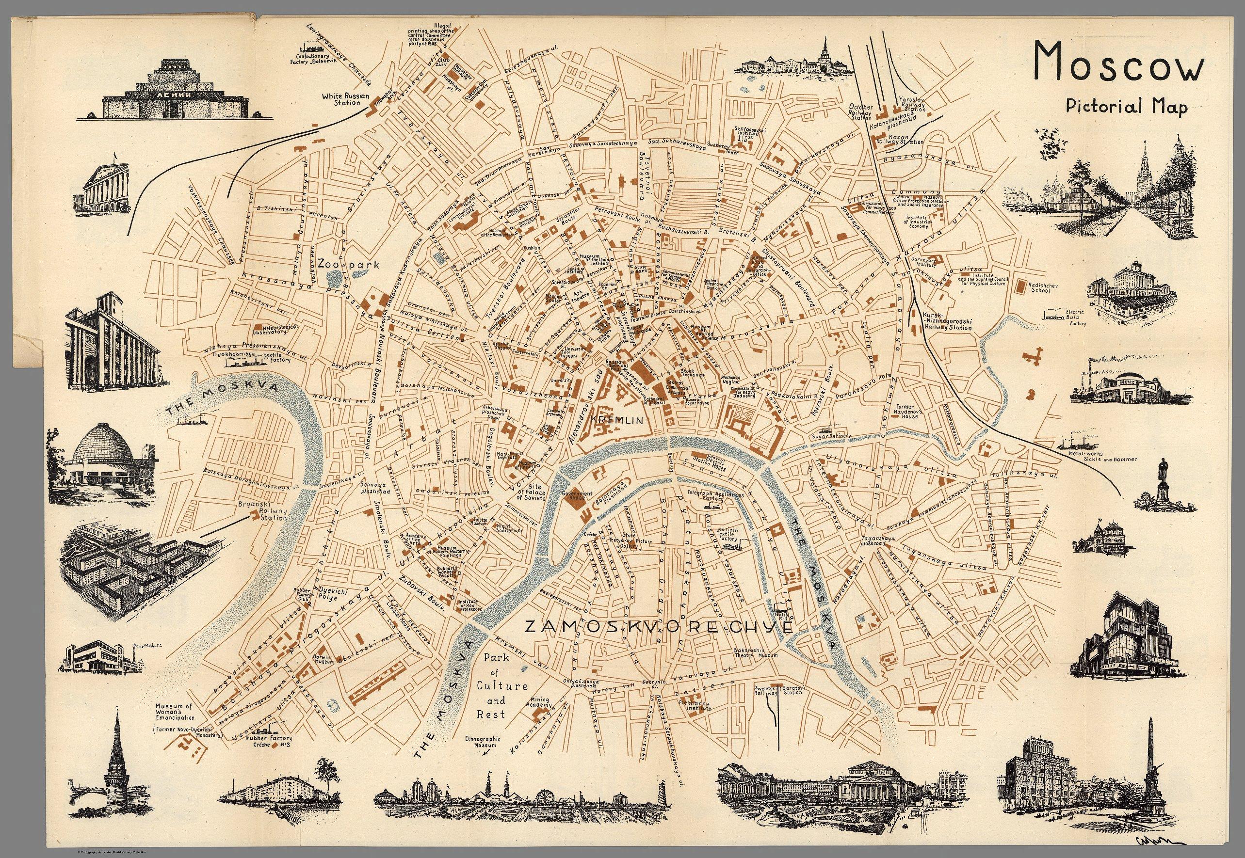
Map of Moscow (USSR, 1960)
Map from a guide for foreign tourists.
Map of Fairy Tale Characters (USA, 1930)
A map for children with images of fairy-tale places and characters with explanatory captions. Very beautiful and funny, show it to your children! Especially for those who are starting to learn English.

European Review. To Kill an Eagle (UK, 1914)

Map of the New World (USA, 1928)
Colonies or possessions of European states are shown in color on the map. The two hemispheres are surrounded by images of historical events, and in the center below is a futuristic picture of a city of the future.