More recently, just 5 years ago, I knew nothing about the tragic fate of hundreds (!) of settlements in the Volga River basin. I had no idea that in the 30-40s of the last century, villages, villages, estates, monasteries and even cities went under water.
The first discovery for me was Kalyazin, with its needle bell tower in the middle of the Volga, as a symbol of everything that happened. Much later, someone told me about Mologa and from then on I began to collect all kinds of information about this place. And finally, in Kashin I bought the book “Cities Under Water” - my heart clench when I imagine how it all happened. Today I want to show you something from this book and the little that I found on the Internet.
We will talk here about Mologa and the Mologa district - here is the epicenter of the Volga tragedy. When filled with water in 1941-1947, 2 cities, about 700 villages with 26 thousand households, 40 parish churches, 3 monasteries, dozens of former noble estates, unexplored archaeological monuments, forests, fields, meadows disappeared under water in the lake part of the Rybinsk reservoir. , which produced the best hay in Russia. An area of developed dairy farming and nationally significant production of high-quality butter and cheese was under water. About 150 thousand people were resettled.

The city of Mologa was located at the confluence of the Mologa River and the Volga. Now this place is located in the southern part of the artificial sea: five kilometers east of the island of Svyatovsky Mokh and three kilometers north of the “Babi Gory” direction sign, standing on the concrete bases of shields that mark the navigable fairway running over the old bed of the Volga.
Mologa from the "Atlas of the Yaroslavl province" 1858.

The city was first mentioned in chronicles in 1149. But it probably arose earlier as an administrative and commercial center at the junction of river routes along which the Slavic colonization of the region took place, which included it in the sphere of influence of Kievan Rus. This could have happened at the turn of the 10th-11th centuries under the Rostov prince Yaroslav the Wise, who “set the land” by determining the size and location of tribute collection. In the XIV-XV centuries, Mologa became the center of the principality. Later, from 1505 to 1777, it was part of the Uglich principality, and then the district. In the 17th-18th centuries the city existed as a trading post. Not far from it, in Stary Kholopye, and then in Mologa itself, there was the largest fair, where Russian, Eastern and European merchants gathered. In 1777, during the period of the provincial reform of Catherine II, Mologa was returned to the status of a city - the center of the district of the same name.
Mologa of the 17th-18th centuries consisted of three settlements: Upper, Middle and Lower, stretching along the banks of the Volga and the Mologa River. During the period of the city's existence as the capital of the principality, there was a Kremlin located in Nizhny Posad, near the confluence of rivers. This place was washed away by water and subsequently, due to the loss of the role of the center of the principality and the status of the city, the Kremlin was no longer restored. The city had a layout typical of the Volga industrial settlements and settlements, in which there was no Kremlin - the city-forming core, and the life of the population was mainly connected with the river.
On March 21, 1780, Catherine II approved the Regular Development Plan for Mologa, developed by the architects of the Urban Development Commission. In the geometric scheme of the new plan, the city largely repeated the old system of organization. By the end of the 19th century, it stretched along the banks of the Volga and Mologa for 4.5 kilometers with four parallel streets. They were intersected by two dozen short alleys, forming a network of neighborhoods, the farthest of which were only 500-800 meters from the banks.
Plan of the city of Mologa from the beginning of the 20th century.
1. Resurrection Cathedral
2. Epiphany Cathedral
3. Church of the Exaltation of the Cross
4. All Saints Church
5. Church of the Ascension "in Zaruchye"
6. Retail area

The picturesque spatial composition and appearance of the main “river facade” of Mologa was formed by five temples standing along the banks.
The oldest of the Youth churches - Ascension "in Zaruchye" in the northern part of the city - was built in 1765. The design of its facades used platbands with a characteristic arched sandstone and other elements of the Baroque style.
Church of the Ascension "in Zaruchye"

The old Resurrection Cathedral (1767) was an ordinary three-part church of the “Naryshkin” style. Despite the reconstruction of the 19th century, the temple and especially its bell tower, composed of three decreasing octagons, repeated the bell towers of earlier churches in Uglich.
Resurrection Cathedral

In the center of the Volga embankment there was a new Epiphany Cathedral (1882), erected at the expense of the Molozhsk merchant of the 1st guild, honorary citizen of the city P.M. Podosenov, in a characteristic “Russian-Byzantine” style.
Epiphany Cathedral

In the southern part of Mologa, in 1778, the wooden Exaltation of the Cross “old cemetery” church was cut down and then plastered. Its tented bell tower, with its clear lines, resembled the bell towers of the temple complexes of northern churchyards, and the temple part of the monument, composed of decreasing octagons, was made in the “Naryshkin” style of the turn of the 17th-18th centuries.
Church of the Exaltation of the Cross

On the outskirts farthest from the shore, the All Saints Cemetery Church, built in 1805 in the strict forms of the classical style, was included in the panorama of the city with its tall, graceful domes and crosses.
Half a kilometer from the northern outskirts of Mologa, on the river bank, was located the Afanasyevsky Convent, which arose in the 14th century. Its extensive complex included 4 churches: the “warm” Trinity Cathedral (1788), the “summer” Cathedral of the Descent of the Holy Spirit (1840), the Church of the Assumption of the Mother of God (1826) and the wooden cemetery church of the Beheading of John the Baptist (1890), which stood not far from the fence. The cell and utility buildings built into the fence and the massive corner rotunda towers gave the ensemble an impressive, monumental appearance. The composition and design of stone churches and most buildings were dominated by classical style forms, and the wooden church was designed in the “Russian” style.
Road to the monastery

Afanasyevsky Convent

On the eve of the flooding, there were more than 900 houses in the city, about a hundred of which were made of stone. On the trade square and the adjacent sections of the main streets there were about 200 shops and shops, as well as public buildings and educational institutions. The population was 7 thousand people. The famous Tikhvin water system began in Mologa - one of the routes from the Volga to the North-West, to the Baltic. In the summer, the city's population increased several times due to loaders, sailors, and watermen. At other times, there were up to 70 taverns in the city.
Mologa city view from the water


Yaroslavskaya street Mologa

central square

Fire station

Distillery

Pond and gazebo in an orphanage

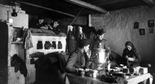
Mologzhans


So what is next...
In September 1935, a resolution was adopted by the Council of People's Commissars of the USSR and the Central Committee of the All-Union Communist Party of Bolsheviks on the start of construction of the Rybinsk and Uglich hydroelectric complexes. The initial project for the creation of the Rybinsk reservoir envisaged the flooding of approximately 2,500 square kilometers (the territory of the state of Luxembourg), mainly along the Sheksna and Mologa rivers, the retaining level of the reservoir was supposed to be 98 m. Many territories of the Mologa region went under water. The city of Mologa was still allowed to live; its main part was located at 98-101 m above sea level and was not subject to flooding. But this seemed not enough. On January 1, 1937, the figure of 98 m was changed to 102 m, which almost doubled the amount of land subject to flooding. It was these 4 meters that cost Mologa his life...
The Rybinsk Museum contains terrible documents telling about those years.

Report
In addition to the report I submitted earlier, I report that there are 294 citizens who voluntarily wished to die with their belongings when the reservoir was filled.
Absolutely all of these people had previously suffered from a nervous health disorder, so the total number of citizens who died during the flooding of the city of Mologa and the villages of the region of the same name remained the same - 294 people.
Among them were those who firmly chained themselves with locks, having previously wrapped themselves around blind objects. Methods of force were applied to some of them, according to the instructions of the NKVD of the USSR.
So Mologa left.
The city finally disappeared in 1947 when the filling of the Rybinsk Reservoir was completed.
Now there is neither a city nor a monastery here. Only occasionally, after a dry summer, on waning autumn days, the foundations of buildings emerge from under the water to remind of themselves. Mologa, like a ghost, appears and disappears in the muddy green shallow waters, frightening and suppressing people who reach it with its landscape, which contains traces of grandiose destruction. Rusty iron of building connections, ruins of unnatural lilac-colored washed bricks, cobblestone pavements, sidewalks half-washed with sand and boulder foundations extending into the water, marking with their rows the direction of the former streets - Yaroslavskaya, Petersburgskaya, Cherepovetskaya... A depressing, creepy-looking “zero cycle”, life-size plan of the entire city. And among this chaos, the basement of the Epiphany Cathedral, which has resisted the pressure of ice and waves and is made of huge granite prisms connected with lead and iron, and the “imprints” of the Resurrection, Ascension and All Saints Churches with fallen cemetery monuments and the contours of the foundations of fences, not yet washed away by sand, are recognizable. And all around is just as lifeless and deserted: in one direction, to the north and east, a gray expanse of water; in the other - to the south and west, kilometers of sands of the briefly exposed reservoir bottom. And among this sandy desert, fantastically improbable temporarily dried islands, crowned with pine manes, float like steppe mirages.
Here are photos taken in the late 1990s - 2000s.


Sad story. Sad ending.