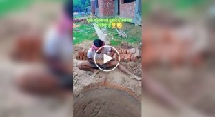
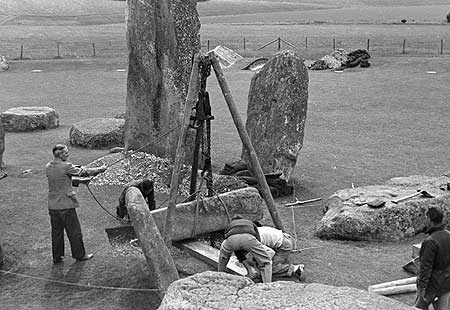
These photographs supposedly depict the construction process of Stonehenge; according to the author of the article, the photographs were taken in 1954. Let's try to figure out what is captured in the photo?
Below is a fragment of the article:

Stonehenge. Filming 1954-1958
At all times, all governments (and especially outside and supra-governmental circles) have engaged in fraud. Photos from 1954 and 1958.

The first reaction of individual readers, who continued to say something about the “excavation”, “restoration”, “replacement” of “ancient megaliths”, convinced that it was still impossible to do without an explanation. In the early photos, starting with the 1st one above, you see white circles indicating places for future “megaliths”. This is the “front of work” for builders. Marking of the object from the customer, made with lime in holes, on a flat, untouched lawn. "Megaliths" are not pulled out like carrots, leaving not the slightest trace of this procedure.
Further, if you look at the photographs more closely, you will find the military, and barbed wire in the surrounding area, and other details indicating that from a certain moment the future “Cyclopean building” of the ancient Druid-Atlanto-Asuro-Siryanto-Aryans was a protected security facility. You will see “customer representatives” who are not officials, builders, workers, or surrounding residents. You will find “initiates” with some bookmarks and equipment. Stonehenge - “space portal”, “energy crystal”, etc., etc. played an important role in ideas associated with “apocalypticism,” “horses,” and so on; this was taken care of when laying it. Until that moment arrives, the purpose of the structure is biological and spiritual contamination. Which is illustrated with modern photographic materials at the end of this post.


The author even cites some, as he calls them, “little known facts”:
1. The first military exercises were held in the Stonehenge area in 1898.
2. From then until World War II, the Department of Defense purchased large tracts of land in the area
3. Currently, the Ministry of Defense owns 390 square kilometers (!) in the immediate vicinity of Stonehenge, some of which are permanently closed, and access to others is severely limited. (According to Wikimapia, the border of the nearest military base is one and a half kilometers from these stones to the north, and the military airstrip is 5 kilometers to the southeast).
4. In the past, a railway line and an airfield were built in the immediate vicinity of Stonehenge, both of which were later dismantled (there are other sources that a military airfield was much closer, at a distance of only one mile from Stonehenge)
5. In 1943, the village of Imber (15 kilometers from Stonehenge) and the village of Par Hinton were evicted. The article about Imber says that to this day the village is under military control
6. 2 kilometers north of Stonehenge is the Royal Artillery School, which conducts real shooting 340 (!) days a year
7. 9 kilometers to the southeast, behind a military airfield, is the Defense Science and Technology Laboratory, whose work is mostly classified.
8. Another 17 kilometers to the west of Stonehenge is a military air corps base and a helicopter airport for combat Apaches.
9. There is no agricultural activity in the Stonehenge area due to the danger of running into an unexploded shell, of which quite a few have accumulated over the century. Because of this, the green meadows around Stonehenge have acquired a Site of Special Scientific Interest as they represent the last natural lawns in England, and possibly in all of Europe.
So, to summarize:
- Around Stonehenge for more than 100 years - a closed area, guarded by the military, patrolled by military aircraft and helicopters, with daily artillery fire.
- Local residents were evicted during the Second World War under the pretext of training exercises; The villages were taken under control by the military, a situation that continues to this day.
- Agricultural activities in the large area of the plain where Stonehenge is located are prohibited
- There was infrastructure on the territory that allowed large-scale construction (including airfields, a railway line), which was subsequently abolished as unnecessary
Perhaps it would be difficult to find a more suitable place for the construction of Stonehenge..."
In other words, everything is very clear. On the territory protected by the British military department, this “center of ancient civilization”, “the legacy of the great ancestors”, “a monument to humanity” was consciously and purposefully erected, which became (not by itself, clearly) the most important religious center of no less purposefully implanted “spirituality” .
There is no doubt that both the “heritage of humanity” itself, and “spirituality”, of which this “heritage” is an important attribute, and “science”, which has developed its “research” around this “heritage” on a colossal scale, have one customer.
p.s. So, what do you think is shown in the photo - the restoration of Stonehenge or the construction of a double?